New map details threat of Zika across Europe, U.S.
LAWRENCE — With Zika sparking anxiety at the Summer Olympic Games in Brazil, and now being transmitted in Florida through contact with mosquitoes, accurately mapping the distribution of the virus is increasingly urgent.
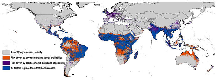
Accounting for a host of often-overlooked drivers of transmission, a team of University of Kansas researchers has mapped Zika risk around the world with unprecedented resolution while considering more factors than previous models.
- The mapping effort uses ecological niche modeling, a technique used to predict distributions of species, to show the virus’ powerful ability to spread in South and Central America.
- This study is the first to evaluate the risk of Zika virus transmission in Europe, which appears relatively low.
- Research suggests parts of the southern U.S., including parts of Florida, Texas and Louisiana, are vulnerable to transmission of the virus.
“It’s the first detailed map that weighs different drivers of transmission,” said Abdallah Samy, who headed the research at the KU Biodiversity Institute. “We assessed different combinations of variables to see what are the major drivers — such as climate, or socioeconomics or people’s ability to access certain areas — and in the final map we merge all the variables.”
The resulting map predicts the likelihood of Zika exposure in the coming years by segmenting Earth’s landmasses into squares of 5-by-5 kilometers each and crunching the numbers for each of them.
Multiple factors influence risk assessment because the virus can spread through contact with mosquitoes in the genus Aedes, person-to-person via sexual contact, through blood transfusions and mother-to-child during pregnancy. The study focused on mosquito-driven transmission.
“For each area, we asked, ‘Is it mosquito exposure, climate or socioeconomic variables like accessibility for people to travel from areas where Zika is endemic and spread the virus upon their return?’” said Samy, who earned a doctorate in ecology and evolutionary biology at KU in May.
The findings recently were posted to the Zika Fast Track site and published in Memórias do Instituto Oswaldo Cruz, an international journal of biological and biomedical research based in Brazil, where the current outbreak has been centered since 2015.
“This map can be used by public health officials and international organizations that combat disease,” Samy said. “It’s also intended for the public. If you’re going to travel to a specific area in Brazil, and you know it’s a risk area for Zika, you should consider how to reduce the chances of transmission with clothing or insect repellant.”
Samy’s co-authors were KU’s A. Townsend Peterson, Stephanie Thomas of the University of Bayreuth in Germany, Ahmed Abd El Wahed of Georg-August University in Germany and Kevin Cohoon (a KU graduate) of the Mayo Clinic.
Samy said the course of the outbreak thus far is similar to what his team’s map predicts with a high degree of specificity.
“We have multiple dimensions in our models, and in addition we use accurate algorithms to account for bias,” he said. “So far, the pattern of spread of cases mostly conform with our model.”
Editors: A larger version of the map above is available.