Kansas Geological Survey to measure groundwater levels in western Kansas
LAWRENCE — A crew from the Kansas Geological Survey, based at the University of Kansas, will be in western Kansas measuring groundwater levels the first week of January.
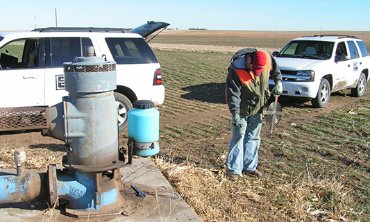
Levels are measured annually as part of a joint project conducted by the KGS and the Kansas Department of Agriculture’s Division of Water Resources (DWR) to monitor the health of the state’s valuable groundwater resources.
Weather permitting, the KGS crew will be working in the following areas:
- Jan. 4: Near Colby and Atwood
- Jan. 5: Goodland and St. Francis
- Jan. 6: Tribune, Syracuse and Ulysses
- Jan. 7: Elkhart and Liberal
- Jan. 8: Meade and Dodge City.
Most of the measured wells tap into the High Plains aquifer, a massive network of underground water-bearing rocks and the main source of water in the region. The rest draw from deeper aquifers or shallower alluvial aquifers along creeks and rivers.
Underlying portions of eight states, the High Plains aquifer in Kansas encompasses three individual ones — the Ogallala aquifer, the Equus Beds around Wichita and Hutchinson, and the Great Bend Prairie aquifer around Pratt and Great Bend. The largest by far, the Ogallala extends into all eight states.
“The Ogallala portion of the Kansas High Plains aquifer, essentially the western third of the state, has seen some level of drought conditions going back to last spring,” said Brownie Wilson, KGS water-data manager. “That is especially true for those counties bordering Colorado.”
The accumulation or lack of precipitation during the growing season influences the amount of pumping, which is the main driver in groundwater level rises and declines. In 2020, extreme drought conditions in late spring and early summer, mainly in southwest Kansas, abated somewhat only to reappear recently, especially across northwest Kansas.
“With such a dry growing season, pumping demands likely will have been higher, and I expect we'll see groundwater declines prevalent across the state,” Wilson said.
Groundwater levels in much of the state’s portion of the Ogallala aquifer, especially in southwest Kansas, have been on the decline since water use started to rise in the mid 20th century.
Because average annual precipitation rates gradually decrease across the state from east to west, the Equus Beds and Great Bend Prairie aquifer receive about 35 and 25 inches per year, respectively, compared to 15 inches along the Colorado border. Also shallower than the Ogallala aquifer, the two central Kansas aquifers are more influenced by recharge — water seeping down from the surface — which makes them less susceptible to permanent losses.
The KGS and DWR measure groundwater levels in December, January and February to avoid, as much as possible, short-term declines caused by widespread pumping during the growing season. Of the 1,428 wells being monitored in 48 counties, the KGS will measure 587, and crews from DWR’s field offices in Garden City, Stafford and Stockton will measure 841.
Many of the wells, accessed with landowners’ permission, have been monitored for years, although new ones are added as older wells become inaccessible or to fill in spatial gaps in the monitoring network. The majority are within the boundaries of the state’s five Groundwater Management Districts (GMDs), which are organized and governed by area landowners and water users to address local water-resource issues.
Historical annual measurements for each well are available at the KGS website. Results of measurements made in January 2021 will be added in late February.