Here’s how you can track a radar plane soaring over South Dakota to gauge snow depths and predict streamflow
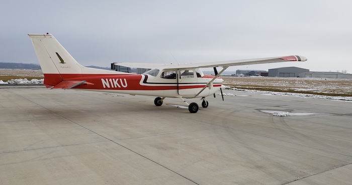
LAWRENCE — Engineers from the University of Kansas School of Engineering and the Center for the Remote Sensing of Ice Sheets (CReSIS) right now are flying a specially equipped Cessna 172 over the Black Hills of South Dakota. It’s a new effort to use airborne radar to measure snow depths and predict how much melting water will fill area streams and rivers.
“We’ve largely only used this radar in Arctic and Antarctic regions — so it’s a new application of the radar to see if it works over highly vegetated areas such as the Black Hills,” said lead researcher Emily Arnold, assistant professor of aerospace engineering at KU. “Josh Roundy in KU civil engineering then is going to use these measurements and try to incorporate them into hydrological models to see if we can better measure and predict how the melting snow will affect the amount of water that’s then flowing into the streams and rivers in the region.”
Supported by a $500,000 grant from the National Oceanographic and Atmospheric Administration (NOAA), the KU Cessna employs a radar specially designed by CReSIS to test spatially continuous measurements of snow depth.
The flights will continue for roughly the next two weeks and can be tracked in real time. The aircraft’s tail number is N1KU.
“We’ve budgeted to be out there for two weeks,” Arnold said. “We will fly around 40 hours, but if it snows, we can’t fly — so we budget for extra days that are going to be down days due to snow when we can’t actually fly, so it’ll be anywhere from 10 to 14 days.”
Garmin has donated new equipment to the KU Cessna to make sure the aircraft is in compliance with updated requirements of the Federal Aviation Administration.
“It’s part of the ADS-B transponder,” Arnold said. “The FAA is revitalizing aviation, and all aircraft are required now to have one of these transponders as of January 1st of this year. So, if you don’t have this, you can’t fly your aircraft. So that’s why it was so important that we were able to get this from Garmin. Basically, it broadcasts your signal as the airplane flies and allows other aircraft to see you. It’s a means for increased safety — now aircraft can see each other flying. Without Garmin’s donation, we would have been in a tough spot to get the aircraft ready in time.”
While the Cessna is operated by a three-person crew made up of KU faculty and staff, graduate students have contributed to many aspects of the project underway over the Black Hills.
“Graduate students have helped with the integration of the radar onto the aircraft, and I’ve had grad students do some structural design analysis,” Arnold said. “Because we fly these weird grid patterns that aren’t necessarily the most efficient, we’ve had a student write a program that tracks the pattern and tells us, ‘Okay, here’s the next line that you should go to, and this is going to be your most efficient flight path,’ which is a new system that we’re going to test out on these flights. Given the limited range of the vehicle, it’s actually quite beneficial if you can save 20 minutes in a flight. When your total flight is maybe three hours, it’s actually rather significant.”
The CReSIS Snow Radar used on the flights is a frequency-modulated, continuous-wave system that operates between 2-8 GHz. It's designed for centimeter-scale sounding of snow layering to depths up to 100 meters in west Antarctica. But the mountainous Black Hills feature ponderosa pine forests, meadows and savannah.
“Historically, we’ve always flown our radars from these much larger aircraft as part of these big airborne campaigns — but this is exciting because it’s all of our own vehicles and radars, so it gives us a lot of flexibility to explore new applications,” Arnold said.
At the conclusion of the flights, which overlap federally operated SNOTEL and USGS stream gauges, the snow-depth data will be crunched by Roundy and integrated into basin-scale models using the Weather Research and Forecasting (WRF)-Hydro model framework.