Geologic map for Lincoln County now available
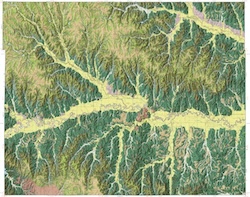
LAWRENCE — The Kansas Geological Survey, based at the University of Kansas, has released a new full-color geologic map of Lincoln County that shows the type and age of rock layers found at or near the surface in the north-central Kansas county. The map identifies deposits of rocks and other materials of economic importance for building roads and construction projects.
The KGS Mapping Advisory Committee, a board consisting of industry and agency representatives that provides guidance and direction to the KGS, chose Lincoln County as a priority mapping site based in part on the Kansas Department of Transportation’s desire to identify occurrences of a calcite-cemented sandstone known as “Lincoln quartzite.”
The “Lincoln quartzite” is a high-quality aggregate much sought after in central Kansas for use in road materials and rip-rap. Aggregate — crushed stone used to make concrete, mortar, asphalt, and other similar products — is an essential component of the concrete and asphalt used to construct roads.
“Aggregates of this quality are uncommon in central Kansas,” said KGS geologist emeritus Robert Sawin. “In eastern Kansas, a variety of limestones meet requirements for high-quality aggregate. In central and western Kansas, however, the necessity of transporting aggregate from so far away increases the cost of construction and maintenance significantly. This map will help KDOT and others identify areas to explore for potential new sources of Lincoln quartzite.”
Sawin and KGS geologist Anthony Layzell are the authors of the map. KGS cartographers Emily Bunse, John Dunham and Kolbe Andrzejewski contributed map layout and database design. The new map also identifies potential sand and gravel deposits throughout the county, providing geologic information needed by engineers and construction companies.
Lincoln County lies in the Smoky Hills physiographic region of the state, where over millions of years, rivers and streams carved through rock layers and created hills and wide, flat river valleys.
Rocks found at the surface in the county are Cretaceous in age, formed 66 to 145 million years ago during a period when advancing and retreating seas covered western and central Kansas. Fossil-rich marine rocks at the surface include the Greenhorn Limestone.
Beds of limestone, chalky limestone, sandstone, and mudrocks are found throughout the county. The oldest, the Kiowa Formation, occurs only in the southeast corner of the county. The Dakota sandstone, formed from delta-type deposits, represents a significant portion of surface rocks. The “Lincoln quartzite” — a calcite-cemented sandstone and not a true quartzite, geologically — is found within the Dakota Formation.
Lincoln County is in the heart of fence-post limestone country. Beginning in the late 1800s, settlers in central Kansas where trees were scarce used rock from the Fence-post limestone bed atop the Greenhorn Limestone for building stone and fence posts.
“Although no longer an important building material, the historical and aesthetic significance of the numerous buildings and fences in the county is noteworthy,” Sawin said. “The geologic map shows the location of a profuse number of abandoned fence-post limestone mines, most of which were probably mined by locals for personal use.”
The contact between the top of the Greenhorn Limestone and the base of the Carlile Shale traces the outcrop of the fence-post limestone throughout the county.
Another area of geologic significance is the “Wilson valley” in the southwest corner of the county.
“The deposit is a source of higher quality sand and gravel but is interesting in that it represents the area where the ancestral Saline River flowed toward the Smoky Hill River during Pleistocene time,” Sawin said.
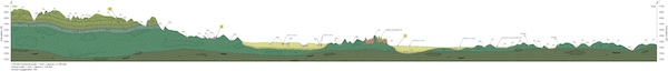
The 59.5-by-45-inch “Surficial Geology of Lincoln County, Kansas” contains the map, as well as a cross section and an illustrated stratigraphic column. Shaded relief provides a three-dimensional quality that accentuates the hills and valleys. The cross section depicts a vertical slice of subsurface rock layers along a line running northwest to southeast across the county.
The stratigraphic column shows the order in which rock units were deposited over time and a description of each unit. Towns and roads — from highways to unimproved roadways — also appear on the map, as do elevation contours at 25-foot intervals and township and range boundaries. The scale is 1:50,000, so that one inch on the map equals about three-quarters of a mile of actual distance. The map can be accessed online.
Geographic information systems (GIS) data for the map will be available for download from the Kansas Data Access and Support Center (DASC), housed at the KGS, and the U.S. Geological Survey National Geologic Map Database catalog. GIS data helps geologists visualize, analyze and interpret the geology of a mapped area.
Paper copies of “Surficial Geology of Lincoln County, Kansas” may be purchased by contacting the KGS publication sales office at 1930 Constant Ave., Lawrence, KS 66047-3724 (phone 785-864-3965 or email kgs-publications@ku.edu) or the KGS’s Kansas Geologic Sample Repository at 4150 W. Monroe St., Wichita, KS 67209-2640 (phone 316-943-2343 ext. 200 or email kgsr@ku.edu). The cost is $20 plus shipping and handling and, for Kansas residents, sales tax.
More information about county geologic maps and other KGS products is available on the KGS website.
The Kansas Geological Survey is a non-regulatory research and service division of the University of Kansas. KGS scientists study and provide information about the state’s geologic resources and hazards, including groundwater, oil and natural gas, rocks and minerals, and earthquakes.